Though I'm sure everyone who reads this already knows full well about the Earth Day installation of The Accretionary Wedge and has likely already read it, I will declare openly and redundantly that people should still go check it out over at Andrew's blog.
For the next issue, I want to know about a geological event you consider most significant to you. That can be a historical event or discovery that pulls in your interest or a more recent event that directly impacted you on a personal level, something that inspires your research or something that changed your approach or results on some work in progress, or whatever else you wish to make of it.
That qualifier of "most significant" can certainly be on a global scale too, but that doesn't also certainly doesn't rule out things that might be completely unheard of to people not studying that particular aspect of geology. I'm most interested in the weight of any given event to you, as scientists and individuals.
I'd like to get the carnival post up on 22 May - the anniversary of the 1960 magnitude 9.5 Valdivia, Chile earthquake, the largest ever recorded. I'd therefore like to have all your posts by 6 PM Pacific time on 21 May, 2008. You can comment on this post with a link, or you can shoot me an email. I'll also post a reminder a few days before things are due.
Tuesday, April 29, 2008
Friday, April 25, 2008
Some paint about 1906
Here's a painting I'd actually hoped to post on 18 April. Turns out it took far longer to finish than planned, due to fiddly detailed bits and also to schoolwork/fieldwork.
I probably should preface it with a little explanation, though. In 2002-2003, I drew a comic book/graphic novel/thing on the premise that the days of the year are personified, with their appearances and personalities based on what happened on that date throughout history. As new significant events happen, those appearances and personalities change. The original thing from 2002-2003 was pretty badly drawn, and focused on September 11th, as my way of coping with those events. In looking back over those drawings for the fifth anniversary of 9-11, though, I figured that it was a waste of a concept to talk about personified days and only really focus on one.
So I went on to April 18th, the Great San Francisco Earthquake and Fire of 1906, a date still very much commemorated for that reason, even though other things certainly have happened on it since. Here's the 16-page comic about April 18th that I drew last year.
The female character is April 18th, and the male character with the sinclines and anticlines on his face is meant to be the personification of the San Andreas Fault. Definitely got a lot of his character design from the Palmdale roadcut.
(That's a whole other story. A friend outright challenged me to figure out how one would go as a fault for Halloween. I did not even try to meet the challenge costume-wise, but this character design was the result on paper.)
And now this painting was this year's commemorative measure on my part:

I feel pretty good about this, particularly considering my usual artistic weapon of choice is markers. I'm kind of concerned that the colors emphasize the fire more than the earthquake, fitting right in with the kind of historical revisionism that gets me all ranty, but I've sort of justified it to myself by realizing that I have no way to know how much of the damage to that original building was caused by the quake and how much by the fire.
The reference photos for both this painting and the pictures of the devastation in the thing from last year come from an awesome book called After the Ruins: 1906 and 2006. Photographer Mark Klett collected a bunch of classic photos of the immediate aftermath of 1906, then went back to those locations in San Francisco and tried to frame the modern day equivalents of the buildings (or at least the same patch of space) in the exact way that the 1906 photos were framed. The facing pages, 1906 and 2006, speak of devastation and of thriving reconstruction all at once, and serve as a reminder of repeatable history. Considering I've monopolized the school library's copy of this book by repeatedly checking it out, I guess it's high time I spit out the cash for my own copy.
I probably should preface it with a little explanation, though. In 2002-2003, I drew a comic book/graphic novel/thing on the premise that the days of the year are personified, with their appearances and personalities based on what happened on that date throughout history. As new significant events happen, those appearances and personalities change. The original thing from 2002-2003 was pretty badly drawn, and focused on September 11th, as my way of coping with those events. In looking back over those drawings for the fifth anniversary of 9-11, though, I figured that it was a waste of a concept to talk about personified days and only really focus on one.
So I went on to April 18th, the Great San Francisco Earthquake and Fire of 1906, a date still very much commemorated for that reason, even though other things certainly have happened on it since. Here's the 16-page comic about April 18th that I drew last year.
The female character is April 18th, and the male character with the sinclines and anticlines on his face is meant to be the personification of the San Andreas Fault. Definitely got a lot of his character design from the Palmdale roadcut.
(That's a whole other story. A friend outright challenged me to figure out how one would go as a fault for Halloween. I did not even try to meet the challenge costume-wise, but this character design was the result on paper.)
And now this painting was this year's commemorative measure on my part:
I feel pretty good about this, particularly considering my usual artistic weapon of choice is markers. I'm kind of concerned that the colors emphasize the fire more than the earthquake, fitting right in with the kind of historical revisionism that gets me all ranty, but I've sort of justified it to myself by realizing that I have no way to know how much of the damage to that original building was caused by the quake and how much by the fire.
The reference photos for both this painting and the pictures of the devastation in the thing from last year come from an awesome book called After the Ruins: 1906 and 2006. Photographer Mark Klett collected a bunch of classic photos of the immediate aftermath of 1906, then went back to those locations in San Francisco and tried to frame the modern day equivalents of the buildings (or at least the same patch of space) in the exact way that the 1906 photos were framed. The facing pages, 1906 and 2006, speak of devastation and of thriving reconstruction all at once, and serve as a reminder of repeatable history. Considering I've monopolized the school library's copy of this book by repeatedly checking it out, I guess it's high time I spit out the cash for my own copy.
Monday, April 21, 2008
More than blue and green...
"Keep our planet blue and green" is one of the Earth Day slogans I remember from the relevant events in which my scout troop participated when I was little. Celebratory banners presented an idealized picture of the globe in those colors, and participants in the event were given small evergreen trees in little pots to plant in the yard, for further promotion of greenness. I suppose blue and green were perfectly reasonable colors to be promoting for the environment in northern Virginia, where I grew up and lived until I was 18, and I really didn't think further into those color-based slogans when I actually paid attention to the holiday.
I didn't see a place to which those colors and the environmental generalizations associated with them really didn't apply until I moved to California in 2006. Sure, I'd seen pictures of deserts, but with those pictures also came the generalization that deserts are wide, flat except for sand dunes, uninhabited, uniformly brown, and full of enormous cacti. But seeing the desert in person - that was a whole different impression. I saw no cacti on my drive across the country, but there were strips and blocks of bare exposed mountains at nearly regular intervals, and I saw plenty of towns stuck in the middle of the sand, trying to be green and welcoming in an environment not so conducive to either.
And I think the colors of the desert are amazing. Brown is only a small part of the story. The palette of the exposed rocks can make the concept of a green swath of vegetation seem too monochromatic and boring. I'm currently taking a mapping class for which our field area is banded in greens, pinks, reds, yellows, creams, and even bright purples, all brightly contrasted against the blue of the sky. The generalized blue and green of streams and trees simply does not apply here, nor should it be made to apply. I have to wonder if the people living in those high desert towns get the same blue and green Earth Day slogans as the folks on the East Coast do, and whether it's deliberate or ignorant that they disregard the colors and characteristics of their local ecosystem in the process of constructing an unnatural environment by hijacking resources from their natural sources, far and wide.
But I digress. Plenty has been written about the development and deconstruction of the desert, far more knowledgeably and articulately than I could do. My point is partially that shooting for the blue and green of Earth Day posters is not the right idea for everywhere on the planet - but also that, while rivers and trees are indeed unique to Earth (as far as we know), the geology that lies underneath that layer - as may be exposed in the desert, for example - is just as unique to our planet and worthy of recognition and celebration on a day whose name suggests devotion to the entire planet.
Friday, April 18, 2008
Sounds of 1906
In the course of compiling that playlist of earthquake-related songs I mentioned a few entries ago, I came across a handful of songs written in the wake of the 1906 San Francisco Earthquake and Fire. It makes absolute sense that with this, like so many other tragedies, reactionary songs popped up within days (if not hours) of the quake. These songs give an interesting snapshot of reactions and how they changed with time, as well as into musical idiom for addressing the public about significant events. I was able to find only sheet music for two of them, two with only recordings, and one with both recording and sheet music.
Interestingly, all five songs are in a major key, despite their images of flames, collapsed buildings, and dead bodies. As someone who has grown up playing music in the Western Art idiom, I was very surprised by this, since it's encoded in music from the beginning of tonality that, generally, major is happy and minor is sad. I would have expected a dirge or a lament. Instead, the songs are not only major, but have an upbeat/dancey piano accompaniment. It occurred to me, though, that the classical idiom is the wrong one from which to look at these. They are, decidedly, the popular music of 1906, and therefore express their feelings in a familiar and accessible - if not overdone - manner for the sake of the audience. It's not any different from that Columbine song written by two students of that school, or many post 9-11/pro-America songs - major key, moderate to fast tempo, nothing compositional (as opposed to lyrical) to distinguish them from any of the popular love songs with which they cohabit the airwaves. I don't know why popular music fell into the habit of major key songs about depressing topics - I'm sure ethnomusicological work has been done on it, or if it hasn't, perhaps it should be.
Four of the songs have words. The fifth, "Firemen's March," is for solo piano. Without the image of San Francisco in flames on the cover of the sheet music, the sound alone could be taken as any perky military (or civil, I suppose) march. The interesting thing about this one is that the cover of the sheet music also declares that the piece was actually composed on 18 April 1906, while the composer was sitting on a hill and watching the subjects of his piece attempt to save the city. To be frank, I think this guy is completely insane. Though the event surely would have inspired me musically (I actually am planning a piece based on it), I would have been sure to get my butt out of the line of fire before I started actually writing anything. I personally get very absorbed in the creative process when composing, and I wouldn't want to be lost to the world scribbling notes while sitting on a hill, only to not notice fire creeping up the back of that hill, or to have an aftershock drop something on me. The composer lived to have his work published, lucky that he was, but I don't think it makes him any less crazy.
The other four songs, for voice and piano, show how the public emphasis of the tragedy shifted away from the earthquake and toward the fire in very little time. The copyright dates on the ones with printed music ("The Stricken City" and "The Burning of Frisco Town") put them in April and May of 1906; judging by the title, I would place "Death Comes at Dawn" closer to the tragedy, and judging from the descriptions of aid in "San Francisco, Our Beloved, Arise," I'd place that one a little later on. The emphasis in the first three songs is on the fire, as was the government-pushed-for goal ("Earthquake? What earthquake? Our ground is safe! Any city can have a fire!") - the mention of the earthquake goes from one verse to one sentence to nothing at all between "Death Comes at Dawn," "The Burning of Frisco Town," and "The Stricken City." "San Francisco, Our Beloved" mentions both earthquake and fire in one sentence, then turning its attention to the important healing process - though hopefully not too soon to heal without learning from what did the breaking to begin with.
"The Burning of Frisco Town," "San Francisco, Our Beloved," and "Death Comes at Dawn" can be heard on this page, toward the bottom. Some lyrics have been modified to mention the date 18 April more specifically, and "Death Comes at Dawn" has been changed to "The Earthquake Came at Dawn," purportedly to "soften the image of the destruction." To me, that's a modern keeping with the revisionism that started in 1906 - if we say "earthquake," but say it as a way to cover the effects, how does that stand for how anyone will cope with the next big one? The San Francisco earthquake and fire were horrific things, both for what they did do, and for how much future is still in them. They should stand up and be retold as a cautionary tale. The old songs, with their denial and coverups, deserve to be played, along with the statement of, "This is how they coped. How will we?"
Thursday, April 10, 2008
At Fault Road Trip, part two
And now, after some delay, Part Two of the fault poking road trip!
Day Four - Parkfield, Carrizo Plain
Abby and I have been to Parkfield several times now, and considering the size of the place, we've pretty much covered our bases for tourism possibilities, particularly since the SAFOD site is not open to the public. We keep going back, though, just plain because we like it - we like how a town full of cattle farmers can still be so very nerdy, we like the full appreciation of seismicity (rather than the SoCal standard of being in denial about it), we like the quietness that comes with being nowhere near the freeway, and we really like the food (and wording of the menu) in the Parkfield Cafe. Not to mention everyone we've ever met there has been really nice. And really, what's a California Fault Tour without a stop in Parkfield?
We ate in the Cafe, then walked over to the bridge over the San Andreas, then went under the bridge, despite signs suggesting we not do so. We then returned to the Cafe with our own nerdy offering. Abby and I have compiled a lengthy list of songs that are either directly related to earthquakes, mention them, or can be construed to be related in the context of the other songs. We figured it would be more fitting to the atmosphere of the Parkfield Cafe than the dreadful soft rock station they had playing, so we brought a copy in. They said, unfortunately, that their CD player probably couldn't handle the MP3 CD, but they still wanted to thank us for the CD and printout of the track list...so they hung it on the wall of the cafe. For those who have not been there, there are all kinds of things lining that wall, mostly articles about Parkfield, maps of regional seismicity, photos of seismological equipment, and cattle farming equipment. We may not have contributed to the ambiance, but our nerdity is now part of the decor! A grand achievement, if I do say so myself...
We followed the directions in David Lynch's incredibly detailed Field Guide to the San Andreas Fault from Parkfield to the Carrizo Plain. This took us down a route called Bitterwater Road, which goes through Palo Prieto Pass and sits pretty much directly on top of the fault the entire time. There are obvious fault features along the route, from scarps to slumps to sags. At this time of year, with sufficient rain, there are also millions of wildflowers in bright blues, oranges, and yellows standing out from the grass. For all the evidence of tectonic torture, this landscape looks very soft when covered with such foliage. Since it's not a busy road, we stopped a few times for photography's sake. Wildflowers and fault features along Bitterwater Road.
We arrived on the Carrizo Plain late enough that we couldn't go explore yet, but still early enough to get a campsite. It was quite windy and chilly at night, but still vastly preferable to the climate in late June.
Day Five - Carrizo Plain
Some of the other campers around our site were members of a group called Desert Survivors, who were there for the wildflowers. They were very nice, and invited us to join them on their hike along Caliente Ridge. We declined, saying we had things to see on the other side of the plain. With this statement, we received general curiosity about what's on the other side. To think, they'd be coming to the Carrizo Plain, site of that ridiculously famous aerial photo, bordered to the east by the Temblor Range, and not know the San Andreas Fault runs through it? Woah.
Our first stop on the other side of the plain was Wallace Creek, another necessity for fault tours. Last time we were there, it was entirely too hot outside and the entire landscape was baked brown. This time, there wasn't exactly any excess moisture, but green was a far more dominant color in the streambed and the rest of the plain as a whole. After Wallace Creek, we went after the Elkhorn Scarp, AKA the Dragon's Backbone. We drove past it in June, but we didn't go through it, and it was way too freaking hot to poke around much anyway. This time, we had Lynch's book to guide us, though we had to follow it backwards since we were coming from the north. This dumped us onto some sketchy dirt road that, for a short while, ran in a dry creek bed. This creek bed crosses the scarp and the fault within it, and it did have some places where I had to turn pretty sharply, but I was concentrating on not slamming the car into a rock or falling into an indentation, and therefore did not actually look for more specific fault features/creek displacements as I was driving. Oops! The place where the road came out on the other side of the scarp did, at least, afford some spectacular views of the pressure ridge. We ate lunch while ogling the landscape, then headed back to camp. The Elkhorn Scarp, viewed from the not-so-sketchy part of the road.
We did decide to go up Caliente Peak after all, but we didn't meet up with any of the Desert Survivors, nor did we go far along the ridgeline, since we didn't want to have to go down the precarious road in the dark. Practically the entire plain is visible, from the white curved expanse of Soda Lake to the raised straight line of the Dragon's Back, to the open expanse patched with varied colors of wildflower. Absolutely beautiful.
Day Six - Carrizo Plain, Roads On Faults
The Carrizo Plain has some outcrops with American Indian pictograms on them, some of which are hidden, and some of which are touristy. The touristy one is only accessible by guided tour at this time of year, though, in order to not freak out the birds that nest there. The outcrop in question is weathered interestingly on the outside, but weathering has also taken its toll on the pictograms. There are some patches of red, white, and black painting still visible on the inside, but much is faded or completely bare. The meaning behind what's left of the paintings is unknown, as is the exact age. It was slightly surreal to be standing there looking at something so far removed from the modern world, both in media and in meaning.
We poked around in the visitors' center for a little while after the tour, before deciding we'd better get going if we wanted to actually see stuff while following the fault back down to SoCal. The main road goes very close to the Elkhorn Scarp, but I was still curious about what the inside looked like, since we'd missed it the previous day. At one point, a small dirt road turned off and looked like it went up up into the pressure ridge, so I was all AHAH and turned up it. It was narrow and kind of windy and high, but I was determined to find the fault! I did, admittedly, stop before the road went all the way up, but that's because it seemed like a good viewing point. The fault was not immediately obvious, since there were three narrow valleys within the pressure ridge, all of which made sense for it to follow. (Of course, if there were multiple fault strands, that'd explain a lot). I guess this is another case of things looking much more clear-cut from the air than from the ground, but I think I'd also need to poke around in this ridge more before saying that for certain.
From Maricopa, the first town you hit when exiting the Carrizo Plain to the south, we kept taking roads that sit on top of the San Andreas. These roads afforded spectacular views of colorful (and landslide-ridden) canyons and linear fault features; around the San Andreas' Big Bend, it went high enough into the mountains that there was still some snow on the ground. We went past the Fort Denial area, and pulled over to get some photos of the junction of the San Andreas and the Garlock, as well as some of the linear ridges and lakes that I saw from the air on the flight from Ontario to Monterey. Around this point, we passed through one of the burn areas from the October 2007 wildfires. It was truly eerie to be driving through a landscape full of twisted leafless trees, their trunks and branches mottled between their natural color and charred black. There was a sign in this part of the forest cautioning travelers about careless use of matches; I wonder whether the sign was put there before or after October. Burnnnn.
We also finally found the Neenach Volcanics - the other half of the Pinnacles - along this route. We'd definitely been looking too far north in June, but we also made the mistake of looking for stuff that actually looked like the Pinnacles. Far from it! Tectonic tilting protected the Pinnacles from weathering, but no such luck for the Neenach formation; it manifests as nondescript outcrops of andesite and rhyolite.
We kept following the San Andreas through to the Cajon Pass, with a stop for dinner in Palmdale (though it was too dark to see the infamous Roadcut). We pulled up to my building in Riverside at around 11 PM.
Day Seven - Not the Landers rupture
The plan for the last day was to go out into the Mojave Desert to find the surface rupture scar from the 1992 Landers earthquake, but the weather forecast said the wind out there was supposed to gust to over 50mph, and we weren't sure if we wanted anything to do with that. We brainstormed some plan Bs, but over brunch at IHOP, we decided to try our luck with the desert anyway.
Susan Hough's Finding Fault in California has directions out to the Emerson Fault section of the rupture, near the northern end, not hugely far from Barstow. These directions were clear up until the "after about seven miles, turn right on a dirt road with no street sign" part. Problem is, the area in which the rupture is supposedly to be found is full of off-roaders, who have made all kinds of trails and roads through the desert. There were a whole bunch of roads onto which we could have turned and still been in the "roughly seven miles" category. We went down about five of them, all said and done, and we didn't find anything. Immediately after the Landers quake, the part of the rupture we were trying to find was supposedly displaced laterally by 15 feet and vertically by 6 feet. That's an impressive scar! Naturally, it would have weathered plenty in sixteen years, but it's doubtful that it would have reduced to completely flat in that time - yet all we found was decidedly undisrupted-looking topography. The only reason we didn't keep looking down more of those dirt roads is the gas meter was telling us things were getting too low for more seeking of surface ruptures in proverbial haystacks or literal creosote fields. As we headed back, we determined that we'll go look for this one again sometime, preferably armed with GPS coordinates and equipment, as well as some more recent descriptions of what to look for.
And that was that for this trip! We're already discussing our next one - or two or three. We'll eventually drive as much of the Garlock Fault as we can manage, and we haven't gone east of the Sierras yet...
Day Four - Parkfield, Carrizo Plain
Abby and I have been to Parkfield several times now, and considering the size of the place, we've pretty much covered our bases for tourism possibilities, particularly since the SAFOD site is not open to the public. We keep going back, though, just plain because we like it - we like how a town full of cattle farmers can still be so very nerdy, we like the full appreciation of seismicity (rather than the SoCal standard of being in denial about it), we like the quietness that comes with being nowhere near the freeway, and we really like the food (and wording of the menu) in the Parkfield Cafe. Not to mention everyone we've ever met there has been really nice. And really, what's a California Fault Tour without a stop in Parkfield?
We ate in the Cafe, then walked over to the bridge over the San Andreas, then went under the bridge, despite signs suggesting we not do so. We then returned to the Cafe with our own nerdy offering. Abby and I have compiled a lengthy list of songs that are either directly related to earthquakes, mention them, or can be construed to be related in the context of the other songs. We figured it would be more fitting to the atmosphere of the Parkfield Cafe than the dreadful soft rock station they had playing, so we brought a copy in. They said, unfortunately, that their CD player probably couldn't handle the MP3 CD, but they still wanted to thank us for the CD and printout of the track list...so they hung it on the wall of the cafe. For those who have not been there, there are all kinds of things lining that wall, mostly articles about Parkfield, maps of regional seismicity, photos of seismological equipment, and cattle farming equipment. We may not have contributed to the ambiance, but our nerdity is now part of the decor! A grand achievement, if I do say so myself...
We followed the directions in David Lynch's incredibly detailed Field Guide to the San Andreas Fault from Parkfield to the Carrizo Plain. This took us down a route called Bitterwater Road, which goes through Palo Prieto Pass and sits pretty much directly on top of the fault the entire time. There are obvious fault features along the route, from scarps to slumps to sags. At this time of year, with sufficient rain, there are also millions of wildflowers in bright blues, oranges, and yellows standing out from the grass. For all the evidence of tectonic torture, this landscape looks very soft when covered with such foliage. Since it's not a busy road, we stopped a few times for photography's sake.
Wildflowers and fault features along Bitterwater Road.We arrived on the Carrizo Plain late enough that we couldn't go explore yet, but still early enough to get a campsite. It was quite windy and chilly at night, but still vastly preferable to the climate in late June.
Day Five - Carrizo Plain
Some of the other campers around our site were members of a group called Desert Survivors, who were there for the wildflowers. They were very nice, and invited us to join them on their hike along Caliente Ridge. We declined, saying we had things to see on the other side of the plain. With this statement, we received general curiosity about what's on the other side. To think, they'd be coming to the Carrizo Plain, site of that ridiculously famous aerial photo, bordered to the east by the Temblor Range, and not know the San Andreas Fault runs through it? Woah.
Our first stop on the other side of the plain was Wallace Creek, another necessity for fault tours. Last time we were there, it was entirely too hot outside and the entire landscape was baked brown. This time, there wasn't exactly any excess moisture, but green was a far more dominant color in the streambed and the rest of the plain as a whole. After Wallace Creek, we went after the Elkhorn Scarp, AKA the Dragon's Backbone. We drove past it in June, but we didn't go through it, and it was way too freaking hot to poke around much anyway. This time, we had Lynch's book to guide us, though we had to follow it backwards since we were coming from the north. This dumped us onto some sketchy dirt road that, for a short while, ran in a dry creek bed. This creek bed crosses the scarp and the fault within it, and it did have some places where I had to turn pretty sharply, but I was concentrating on not slamming the car into a rock or falling into an indentation, and therefore did not actually look for more specific fault features/creek displacements as I was driving. Oops! The place where the road came out on the other side of the scarp did, at least, afford some spectacular views of the pressure ridge. We ate lunch while ogling the landscape, then headed back to camp.
The Elkhorn Scarp, viewed from the not-so-sketchy part of the road.We did decide to go up Caliente Peak after all, but we didn't meet up with any of the Desert Survivors, nor did we go far along the ridgeline, since we didn't want to have to go down the precarious road in the dark. Practically the entire plain is visible, from the white curved expanse of Soda Lake to the raised straight line of the Dragon's Back, to the open expanse patched with varied colors of wildflower. Absolutely beautiful.
Day Six - Carrizo Plain, Roads On Faults
The Carrizo Plain has some outcrops with American Indian pictograms on them, some of which are hidden, and some of which are touristy. The touristy one is only accessible by guided tour at this time of year, though, in order to not freak out the birds that nest there. The outcrop in question is weathered interestingly on the outside, but weathering has also taken its toll on the pictograms. There are some patches of red, white, and black painting still visible on the inside, but much is faded or completely bare. The meaning behind what's left of the paintings is unknown, as is the exact age. It was slightly surreal to be standing there looking at something so far removed from the modern world, both in media and in meaning.
We poked around in the visitors' center for a little while after the tour, before deciding we'd better get going if we wanted to actually see stuff while following the fault back down to SoCal. The main road goes very close to the Elkhorn Scarp, but I was still curious about what the inside looked like, since we'd missed it the previous day. At one point, a small dirt road turned off and looked like it went up up into the pressure ridge, so I was all AHAH and turned up it. It was narrow and kind of windy and high, but I was determined to find the fault! I did, admittedly, stop before the road went all the way up, but that's because it seemed like a good viewing point. The fault was not immediately obvious, since there were three narrow valleys within the pressure ridge, all of which made sense for it to follow. (Of course, if there were multiple fault strands, that'd explain a lot). I guess this is another case of things looking much more clear-cut from the air than from the ground, but I think I'd also need to poke around in this ridge more before saying that for certain.
From Maricopa, the first town you hit when exiting the Carrizo Plain to the south, we kept taking roads that sit on top of the San Andreas. These roads afforded spectacular views of colorful (and landslide-ridden) canyons and linear fault features; around the San Andreas' Big Bend, it went high enough into the mountains that there was still some snow on the ground. We went past the Fort Denial area, and pulled over to get some photos of the junction of the San Andreas and the Garlock, as well as some of the linear ridges and lakes that I saw from the air on the flight from Ontario to Monterey. Around this point, we passed through one of the burn areas from the October 2007 wildfires. It was truly eerie to be driving through a landscape full of twisted leafless trees, their trunks and branches mottled between their natural color and charred black. There was a sign in this part of the forest cautioning travelers about careless use of matches; I wonder whether the sign was put there before or after October.
 Burnnnn.
We also finally found the Neenach Volcanics - the other half of the Pinnacles - along this route. We'd definitely been looking too far north in June, but we also made the mistake of looking for stuff that actually looked like the Pinnacles. Far from it! Tectonic tilting protected the Pinnacles from weathering, but no such luck for the Neenach formation; it manifests as nondescript outcrops of andesite and rhyolite.
We kept following the San Andreas through to the Cajon Pass, with a stop for dinner in Palmdale (though it was too dark to see the infamous Roadcut). We pulled up to my building in Riverside at around 11 PM.
Day Seven - Not the Landers rupture
The plan for the last day was to go out into the Mojave Desert to find the surface rupture scar from the 1992 Landers earthquake, but the weather forecast said the wind out there was supposed to gust to over 50mph, and we weren't sure if we wanted anything to do with that. We brainstormed some plan Bs, but over brunch at IHOP, we decided to try our luck with the desert anyway.
Susan Hough's Finding Fault in California has directions out to the Emerson Fault section of the rupture, near the northern end, not hugely far from Barstow. These directions were clear up until the "after about seven miles, turn right on a dirt road with no street sign" part. Problem is, the area in which the rupture is supposedly to be found is full of off-roaders, who have made all kinds of trails and roads through the desert. There were a whole bunch of roads onto which we could have turned and still been in the "roughly seven miles" category. We went down about five of them, all said and done, and we didn't find anything. Immediately after the Landers quake, the part of the rupture we were trying to find was supposedly displaced laterally by 15 feet and vertically by 6 feet. That's an impressive scar! Naturally, it would have weathered plenty in sixteen years, but it's doubtful that it would have reduced to completely flat in that time - yet all we found was decidedly undisrupted-looking topography. The only reason we didn't keep looking down more of those dirt roads is the gas meter was telling us things were getting too low for more seeking of surface ruptures in proverbial haystacks or literal creosote fields. As we headed back, we determined that we'll go look for this one again sometime, preferably armed with GPS coordinates and equipment, as well as some more recent descriptions of what to look for.
And that was that for this trip! We're already discussing our next one - or two or three. We'll eventually drive as much of the Garlock Fault as we can manage, and we haven't gone east of the Sierras yet...
Monday, April 7, 2008
We interrupt this message for a brief announcement...
Guess who's now officially accepted for a MS in Earthquake Physics?
Awww YEAHHH!
(Methinks I should not do a victory dance while in the music building. Also, now I need to figure out how to break the news to the department head and to my private teacher. I fear an explosive reaction from the latter. I don't think coming to my lesson wearing a t-shirt that says "SEISMOLOGIST" will work so well.)
We will return to our regularly scheduled field trip description shortly.
Friday, April 4, 2008
At Fault Road Trip, part one
For those of you have been questioning (or celebrating) my absence, I assure you I am still not dead, and still have not fallen into the ocean. Unlike the last time I said this, I was away from my computer for good and relaxing reasons, rather than drowning in a pile of Western Art Music history and theory. For all of last week, Monday through Sunday, my friend Abby and I were traipsing around California in search of major faults. Naturally, we had a large pool of possibilities from which to pick our sites, but I think we chose good ones. We admittedly did this trip with more touristing than geologizing - we looked for offset sidewalks and signs of scarp, but took no measurements or detailed field notes (though I did keep a paper journal about it, and we both took gajillions of photos). Regardless of the mostly-nonscientificness of this trip, we still got called huge nerds for doing this over our spring break by a woman in a store in Hollister. Success!
Day One - Airplane, Monterey
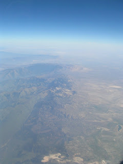
At last, I get to participate in the Airliner Chronicles! This is the Garlock Fault and Tehachapi Mountains.
We started the trip up in Soledad, which is in Monterey County off the 101, and I opted to fly up there for the sake of time (and because the last time I did that drive, it resulted in the accident I posted photos of earlier this year). Turns out that the flight from Ontario, CA to Monterey is one that simply cannot be missed by people who like faults and geomorphology. In that short hour, one gets a fantastic (and different!) view of so many things that it would easily take days to get to it all by car. My seat was on the right side, and I could see the clear linear trace of the San Andreas from behind the San Gabriel Mountains to where it intersects the Garlock in the Mojave. I didn't quite get to see the sharp angle exactly where the two faults meet, but it was still clear they were coming to that end based on the slant of their respective mountain ranges. For a while, there was only Central Valley out the right, with the tips of the Sierras in the far distance, but I was able to angle myself so that I could get some really good looks at the Carrizo Plain out the left side of the plane. We crossed back so the San Andreas was on the right somewhere near Parkfield, which I am about 80% sure I saw out the window. On the descent, there was a really nice view of the Pinnacles. I took about 20 pictures out the window of the plane. Next time I make this flight, I want to sit on the other side!
After the flight, we took a nice hike on the old Fort Ord lands, which are built on relic sand dunes. Unfortunately, most of the rocks one finds on these trails are chunks of asphalt left over from the military, when they ripped up their roads upon decommissioning the fort, but it's still a very pleasant place to hike.
Day Two - Hollister, San Juan Bautista, Hayward

This house, in Hollister, has an unwanted guest named Calaveras...
Abby and I have been to Hollister before - we went during the summer, as part of another fault-poking trip. Thus, we'd already seen the craziness that aseismic creep has inflicted on the town. We wanted to see it again, to look for details we might have missed, but we also had the objective of trying to get the town to live up to some things. According to Wikipedia, as well as some other hits on Google, Hollister claims to be the Earthquake Capitol of the World. Parkfield, however, also claims the same thing, and Parkfield had t-shirts and bumper stickers to back up their claim. Hollister didn't seem to have anything to back it up the first time we went, so we searched more actively this time. Turns out that Hollister has officially dropped its hold on the title, precisely because Parkfield started having more earthquakes than Hollister did. We still were able to find some t-shirts with the old slogan, though, so we left happily.
After a brief detour to check out the Mission San Juan Bautista, which is built on a nice scenic hill with a great view, which also happens to be a scarp of the San Andreas Fault, we headed on to Hayward. Traffic was, for the most part, ok, and we got to our hotel with about an hour of daylight to spare. We chose this hotel (a Days Inn) because it was cheap and not gross, not for fault-related proximity, but we decided we'd try to see our first evidence of aseismic creep before darkness fell. Susan Hough's Finding Fault in California, which we consider something of an Indispensable Fault-Poking Guide, told us, with no great fanfare, that the fault was on the same block as the hotel. We felt the warning bells anyway, and a quick consultation with Google Earth and the USGS's quaternary faults overlay told us that the Hayward Fault was, in fact, directly on the other side of the wall, fifteen feet from where we were sitting. That's probably why the hotel was cheap! That explains the long narrow hill behind the building! Cue nervous laughter that went off and on for the rest of the evening. We found no evidence of creep on the hotel itself, though there was a deflected curb the next block over. Good enough for us to call it a night, after imploring through the wall that the fault be nice to us.
Day Three - Hayward, Berkeley, Crystal Springs Reservoir
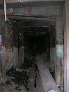
The view into the Lawson Adit, Berkeley
After breakfast, we went on the "classic" aseismic creep walking tour of downtown Hayward. From this tour, it was immediately apparent that the city of Hayward tries hard to cover up what Hollister leaves plain for all to see. The Hayward Fault has a bigger scarp than the Calaveras, on which there are plenty of houses built, but the city has done a good job of erasing much of the creep. Rather than looking for bent and broken sidewalks, fresh new concrete is a better way for locating the fault. There is one curb, at the corner of Rose and Prospect streets, that has managed to escape erasure. My guess is that people fought for it to stay in its gloriously displaced state, since the other three corners of the intersection look freshly refurbished. The fourth corner, however, shows about a foot of offset. Apparently it's been there since the '70s, and someone occasionally puts a dated line across it as a makeshift creep meter. It will be a sad day when that curb gets fixed.
Another salient point of the Hayward walking tour was Old City Hall. This is a beautiful old building from the late 19th century that has the unfortunate position of being directly on top of the fault. It was maintained for a long time, but was finally abandoned for being structurally unsound in the 1990s. It still stands, slowly being pulled apart, as a sad symbol of what happens when people don't plan around what nature can do. Peering into the broken windows, one can see rows of cracks around pillars and in the ceiling, which align with an oft-patched sidewalk outside. There are also still remnants of more human things - a wooden mailbox for Santa in an otherwise empty room, and a wall covered with children's faded crayon drawings. I wonder if the kids who drew them, who were probably so proud to give them to their parents, know that the only audience for them now is the Hayward Fault. The front door of the hall only says that it has moved to a new location, not why the move had to occur. The cool thing about the new hall, though, is that it maintains some of the design elements - ornamentation, the way the lettering "Hayward City Hall" is carved into the stone - of the old, while still being a completely different looking structure. It's a nice fusion, and made all the nicer by a mural on the parking structure between the two halls, which depicts people carrying chunks of the design of the old hall around to the new one. Hayward, you handled it gracefully.
Our next stop was Berkeley, where we met up with none other than Maria, who was awesome enough to take a break from Thesis Hell to give us the Geek Tour of her campus. Like in Hayward, Berkeley generally does a pretty good job of hiding its faults, though there are some places that the Hayward Fault still makes itself known. The most famous example is the Cal Memorial Stadium, which is a pretty terrifying structure even without the whole aseismic creep thing. The outside is unreinforced concrete, and all the seats and floors in front of them are wood - all of which is wobbly, some of which is also rotting. I doubt this thing even needs something as significant as The Big One to bring it down. But there is also the fault, which, while it runs through section LL, shows huge creeping cracks in the wall and tilts in the foundation at section KK. You can easily see the parking lot through this hole. You can practically see San Francisco through this hole. After taking some pictures, we got the heck out of there, lest our magnitude of sheer nerditude bring the structure down. I think the stadium was also scarier than the view into the Lawson Adit, which was a late 19th century teaching mining tunnel that happens to also go into the fault, through its medieval-dungeon-esque door. The rest of the fault features were more subtle, in the form of a gently curving stream and some slightly bent streets. The rest of the geekery between the three of us was as blatant as two Wallace Creeks put together.
Abby and I left Maria to do her thesis, taking the scenic route back from Berkeley. We went over the Oakland Bay Bridge, though we could not tell which specific section had been Loma Prieta'd, then through the San Francisco Peninsula on I-280. This freeway passes through the San Andreas Valley, where the Fault was first identified and from which the fault took its name. We tried to pull over and take a brief walk along Crystal Springs Reservoir, which is a long lake along the fault, filled with water due to a manmade dam, but we went to the wrong parking lot and gave up, since we didn't want to be searching until it got dark. I did pick up some neat samples of serpentinite on this walk, though, and we did eventually drive past the dam on the way back to the freeway. We still made good time back to Soledad despite the detour.
Aaaand this is turning long. I think I'll cover the other four days in a second entry.
Subscribe to:
Posts (Atom)